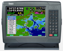
10.4-inch Marinee GPS XF-1069
Description
? High brightness, wide viewing angle, LED backlit LCD screen.
? Navigating live voice announcements.
? The nautical chart covers the coastal areas of China, the Yangtze River, the Beijing Shipping River and other inland lakes and Southeast Asia, and the chart and software can be upgraded free of charge.
? AIS input port for easy connection to AIS equipment, dynamically plot AIS targets on charts.
? Stepless backlight adjustment, multiple adjustment modes, comfortable night use mode.
? Beautiful and stylish appearance, sealed and waterproof.
? The front USB flash drive upgrades the chart and software, and can also back up and copy user data.
? Wide voltage design, DC12V~36V, with anti-reverse protection of positive and negative poles.
? Installation method: embedded installation and countertop installation.
? Waterproof rating: IPX6.
? 2-way NMEA0183 GPS data output.
Parameters
Screen Type | Color TFT LCD |
Screen Size | 10.4-inch |
Resolution | 640×480px(WVGA) |
Scren Brightness | 550cd/㎡ |
Language | English; Simplified Chinese; Traditional Chinese |
Storage | 6000 waypoints, 200 routes (48 points each), 10,000 points, 200 lines (40 points each), 800 tracks (maximum 20480 points each) |
Interface | GPS output 1 channel, AIS output 2 channels, 0183 input 1 channel |
Chart | XINUO |
Other Functions | AIS Real-time monitor system |
Operating Temperature | -15℃~+55℃ |
Waterproof Level | IPX6 |
Power Supply | 12V~36V DC |


